
بحث جديد يستخدم الذكاء الاصطناعي وصور الأقمار الصناعية للكشف عن البصمة المتزايدة للنشاط البشري في البحر
واشنطن العاصمة ، 03 ، 2024
دراسة جديدة نشرت اليوم في مجلة نيتشر يقدم وجهة نظر غير مسبوقة من الاستخدام الصناعي غير المعين سابقا للمحيط وكيف يتغير.
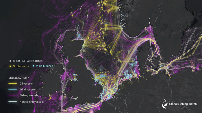
الدراسة الرائدة, بقيادة مراقبة الصيد العالمية, يستخدم التعلم الآلي وصور الأقمار الصناعية لإنشاء أول خريطة عالمية لحركة السفن الكبيرة والبنية التحتية البحرية, العثور على قدر ملحوظ من النشاط الذي كان في السابق "مظلما" لأنظمة المراقبة العامة.
يكشف التحليل أن حوالي 75 في المائة من سفن الصيد الصناعية في العالم لا يتم تعقبها علنا ، حيث يتم الكثير من هذا الصيد في جميع أنحاء إفريقيا وجنوب آسيا. أكثر من 25 في المائة من نشاط سفن النقل والطاقة مفقود أيضا من أنظمة التتبع العامة.
قال ديفيد كرودسما ، مدير البحث والابتكار في منظمة مراقبة الصيد العالمية والمؤلف الرئيسي المشارك للدراسة:" لقد ظهرت ثورة صناعية جديدة في بحارنا دون أن يتم اكتشافها—حتى الآن". "على الأرض ، لدينا خرائط مفصلة لكل طريق تقريبا ومبنى على هذا الكوكب. في المقابل ، تم إخفاء النمو في محيطنا إلى حد كبير عن الأنظار العامة. تساعد هذه الدراسة في القضاء على البقع العمياء وإلقاء الضوء على اتساع وشدة النشاط البشري في البحر.”
قام باحثون من منظمة مراقبة الصيد العالمية وجامعة ويسكونسن ماديسون وجامعة ديوك وجامعة كاليفورنيا في سانتا باربرا وسكيتروث بتحليل 2 مليون غيغابايت من صور الأقمار الصناعية التي تمتد من 2017 إلى 2021 للكشف عن السفن والبنية التحتية البحرية في المياه الساحلية عبر ست قارات حيث يتركز أكثر من ثلاثة أرباع النشاط الصناعي.
من خلال تجميع بيانات نظام تحديد المواقع العالمي مع خمس سنوات من الرادار والصور البصرية ، تمكن الباحثون من تحديد السفن التي فشلت في بث مواقعها. وباستخدام التعلم الآلي ، استنتجوا بعد ذلك أي من هذه السفن من المحتمل أن تشارك في نشاط صيد الأسماك.
"تاريخيا ، تم توثيق نشاط السفن بشكل سيئ ، مما يحد من فهمنا لكيفية استخدام أكبر مورد عام في العالم—المحيط—" قال المؤلف الرئيسي المشارك فرناندو باولو ، كبير مهندسي التعلم الآلي في مراقبة الصيد العالمية. "من خلال الجمع بين تكنولوجيا الفضاء والتعلم الآلي الحديث ، قمنا برسم خريطة للنشاط الصناعي غير المعلن في البحر على نطاق لم يتم القيام به من قبل.”
على الرغم من أن جميع القوارب ليست ملزمة قانونا ببث مواقعها ، إلا أن السفن الغائبة عن أنظمة المراقبة العامة ، والتي يطلق عليها غالبا "الأساطيل المظلمة" ، تشكل تحديات كبيرة لحماية الموارد الطبيعية وإدارتها. وجد الباحثون العديد من سفن الصيد المظلمة داخل العديد من المناطق البحرية المحمية ، وتركيزا مرتفعا للسفن في مياه العديد من البلدان التي أظهرت سابقا نشاطا ضئيلا أو معدوما للسفن بواسطة أنظمة المراقبة العامة.
"تشير البيانات المتاحة للجمهور بشكل خاطئ إلى أن آسيا وأوروبا لديهما كميات مماثلة من الصيد داخل حدودهما ، لكن رسم الخرائط لدينا يكشف أن آسيا تهيمن—مقابل كل 10 سفن صيد وجدناها على الماء ، كانت سبع سفن في آسيا بينما كانت واحدة فقط في أوروبا" ، قالت المؤلفة المشاركة جينيفر رينور ، أستاذة مساعدة في اقتصاديات الموارد الطبيعية في جامعة ويسكونسن ماديسون. "من خلال الكشف عن السفن المظلمة ، أنشأنا الصورة العامة الأكثر شمولا للصيد الصناعي العالمي المتاح.”
تظهر الدراسة أيضا كيف يتغير النشاط البشري في المحيط. وبالتزامن مع جائحة كوفيد-19 ، انخفض نشاط الصيد على مستوى العالم بنحو 12 في المائة ، مع انخفاض بنسبة 8 في المائة في الصين وانخفاض بنسبة 14 في المائة في أماكن أخرى. في المقابل ، ظل نشاط سفن النقل والطاقة مستقرا.
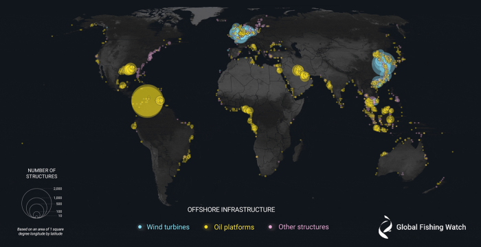
ارتفع تطوير الطاقة البحرية خلال فترة الدراسة. زادت الهياكل النفطية بنسبة 16 في المائة ، بينما زادت توربينات الرياح بأكثر من الضعف. بحلول عام 2021 ، فاق عدد التوربينات عدد منصات النفط. حققت طاقة الرياح البحرية في الصين النمو الأكثر لفتا للانتباه ، حيث زادت تسعة أضعاف من عام 2017 إلى عام 2021.
قال المؤلف المشارك باتريك هالبين ، أستاذ البيئة الجغرافية المكانية البحرية بجامعة ديوك:" لم تعد بصمة الأنثروبوسين تقتصر على تيرا فيرما". "إن وجود رؤية أكثر اكتمالا لتصنيع المحيطات يسمح لنا برؤية نمو جديد في الرياح البحرية وتربية الأحياء المائية والتعدين الذي يتم إضافته بسرعة إلى أنشطة الصيد الصناعي والشحن والنفط والغاز. يكشف عملنا أن المحيط العالمي هو مساحة عمل صناعية مزدحمة ومزدحمة ومعقدة للاقتصاد الأزرق المتنامي.”
تسلط الدراسة الضوء على إمكانات هذه التكنولوجيا الجديدة لمعالجة تغير المناخ. سيؤدي رسم خرائط جميع حركة السفن إلى تحسين تقديرات انبعاثات غازات الاحتباس الحراري في البحر ، بينما يمكن لخرائط البنية التحتية أن تفيد في تطوير الرياح أو تساعد في تتبع التدهور البحري الناجم عن التنقيب عن النفط.
وقال المؤلف المشارك كريستيان توماس ، وهو مهندس جغرافي مكاني في سكيتروث:" يعد تحديد البنية التحتية البحرية أمرا بالغ الأهمية لفهم تأثيرات واتجاهات تطوير الطاقة البحرية ، وهو بيانات حاسمة لعملنا للكشف عن أحداث التلوث البحري ومحاسبة الأطراف المسؤولة".
يمكن للبيانات والتكنولوجيا المفتوحة المستخدمة في الدراسة أن تساعد الحكومات والباحثين والمجتمع المدني على تحديد النقاط الساخنة للنشاط غير القانوني المحتمل ، وتحديد الأماكن التي قد تتعدى فيها سفن الصيد الصناعية على مناطق الصيد الحرفي ، أو ببساطة فهم حركة السفن في مياهها بشكل أفضل.
"في السابق ، كان هذا النوع من مراقبة الأقمار الصناعية متاحا فقط لأولئك الذين يمكنهم دفع ثمنه. الآن هو متاح مجانا لجميع الدول" ، واختتم كرودسما. "تمثل هذه الدراسة بداية حقبة جديدة في إدارة المحيطات والشفافية.”
New research harnesses AI and satellite imagery to reveal the expanding footprint of human activity at sea
Study reveals 75 percent of the world’s industrial fishing vessels are hidden from public view
WASHINGTON, D.C., 03, 2024
A new study published today in the journal Nature offers an unprecedented view of previously unmapped industrial use of the ocean and how it is changing.
The groundbreaking study, led by Global Fishing Watch, uses machine learning and satellite imagery to create the first global map of large vessel traffic and offshore infrastructure, finding a remarkable amount of activity that was previously “dark” to public monitoring systems.
The analysis reveals that about 75 percent of the world’s industrial fishing vessels are not publicly tracked, with much of that fishing taking place around Africa and south Asia. More than 25 percent of transport and energy vessel activity are also missing from public tracking systems.
“A new industrial revolution has been emerging in our seas undetected—until now,” said David Kroodsma, director of research and innovation at Global Fishing Watch and co-lead author of the study. “On land, we have detailed maps of almost every road and building on the planet. In contrast, growth in our ocean has been largely hidden from public view. This study helps eliminate the blind spots and shed light on the breadth and intensity of human activity at sea.”
Researchers from Global Fishing Watch, the University of Wisconsin-Madison, Duke University, UC Santa Barbara and SkyTruth analyzed 2 million gigabytes of satellite imagery spanning 2017-2021 to detect vessels and offshore infrastructure in coastal waters across six continents where more than three-quarters of industrial activity is concentrated.
By synthesizing GPS data with five years of radar and optical imagery, the researchers were able to identify vessels that failed to broadcast their positions. Using machine learning, they then concluded which of those vessels were likely engaged in fishing activity.
“Historically, vessel activity has been poorly documented, limiting our understanding of how the world’s largest public resource—the ocean—is being used,” said co-lead author Fernando Paolo, senior machine learning engineer at Global Fishing Watch. “By combining space technology with state-of-the-art machine learning, we mapped undisclosed industrial activity at sea on a scale never done before.”
While not all boats are legally required to broadcast their position, vessels absent from public monitoring systems, often termed “dark fleets,” pose major challenges for protecting and managing natural resources. Researchers found numerous dark fishing vessels inside many marine protected areas, and a high concentration of vessels in many countries’ waters that previously showed little-to-no vessel activity by public monitoring systems.
“Publicly available data wrongly suggests that Asia and Europe have similar amounts of fishing within their borders, but our mapping reveals that Asia dominates—for every 10 fishing vessels we found on the water, seven were in Asia while only one was in Europe," said co-author Jennifer Raynor, assistant professor of natural resource economics at the University of Wisconsin-Madison. “By revealing dark vessels, we have created the most comprehensive public picture of global industrial fishing available.”
The study also shows how human activity in the ocean is changing. Coinciding with the COVID-19 pandemic, fishing activity dropped globally by about 12 percent, with an 8 percent decline in China and a 14 percent drop elsewhere. In contrast, transport and energy vessel activity remained stable.
Offshore energy development surged during the study period. Oil structures increased by 16 percent, while wind turbines more than doubled. By 2021, turbines outnumbered oil platforms. China’s offshore wind energy had the most striking growth, increasing ninefold from 2017 to 2021.
“The footprint of the Anthropocene is no longer limited to terra firma,” said co-author Patrick Halpin, professor of marine geospatial ecology at Duke University. “Having a more complete view of ocean industrialization allows us to see new growth in offshore wind, aquaculture and mining that is rapidly being added to established industrial fishing, shipping and oil and gas activities. Our work reveals that the global ocean is a busy, crowded and complex industrial workspace of the growing blue economy.”
The study highlights the potential of this new technology to tackle climate change. Mapping all vessel traffic will improve estimates of greenhouse gas emissions at sea, while maps of infrastructure can inform wind development or aid in tracking marine degradation caused by oil exploration.
“Identifying offshore infrastructure is critical for understanding offshore energy development impacts and trends, and is crucial data for our work to detect marine pollution events and hold responsible parties to account,” said co-author Christian Thomas, a geospatial engineer at SkyTruth.
The open data and technology used in the study can help governments, researchers and civil society to identify hotspots of potentially illegal activity, determine where industrial fishing vessels may be encroaching on artisanal fishing grounds, or simply better understand vessel traffic in their waters.
“Previously, this type of satellite monitoring was only available to those who could pay for it. Now it is freely available to all nations,” concluded Kroodsma. “This study marks the beginning of a new era in ocean management and transparency.”